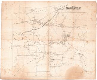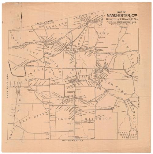
Map of Manchester, Connecticut
SurveyorSurveyed by
Eli Bissell
(American, 1786 - 1866)
PrinterPrinted by
Kelloggs & Comstock
(American, 1848 - 1850)
Date1849
MediumLithography; printer's ink on wove paper
DimensionsPrimary Dimensions (image height x width): 11 7/8 x 12in. (30.2 x 30.5cm)
Sheet (height x width): 13 1/2 x 13 1/2in. (34.3 x 34.3cm)
Sheet (height x width): 13 1/2 x 13 1/2in. (34.3 x 34.3cm)
ClassificationsGraphics
Credit LineConnecticut Museum of Culture and History collection
DescriptionMap of Manchester, Connecticut, from the town line of South Windsor to the north, Vernon and Bolton to the east, Glastonbury (spelled "Glastenbury" on the map) to the south, and East Hartford to the west. The town is divided into districts: the Oakland District, North West District, North District, East District, West District, South East District, South West District, South District and Birch Mountain District. Roads worth noting include the Providence Turnpike, Tolland Turnpike, and the south road to Hartford. The Hockanum River runs southwest through town toward East Hartford. The Hartford and Providence Railroad runs east-west through town. Residences are marked with circles and the owner's name. Cemeteries, schoolhouses, mills, churches, and Wyllys Copper Mine are depicted, as well.
Object number2012.312.24
NotesCartographic Note: Scale: 4 inches equals one mileOn View
Not on view