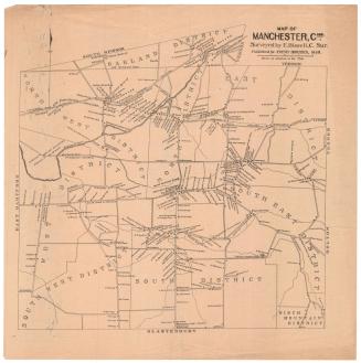
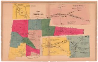
Map of the Town of Manchester
DraftsmanDrawn by
Herbert R. Fitch
(American, 1868 - 1958)
PrintmakerEngraved by
Edward F. Fisk
(American, 1857 - after 1915)
PublisherPublished by
Arthur E. Bowers
(American, 1855 - 1925)
Date1896
MediumLithography; black printer's ink on wove paper
DimensionsPrimary Dimensions (image height x width): 13 1/2 x 13 7/8in. (34.3 x 35.2cm)
Sheet (height x width): 17 x 16 7/8in. (43.2 x 42.9cm)
ClassificationsGraphics
Credit LineConnecticut Museum of Culture and History collection
Object number2012.312.23
DescriptionMap of Manchester, Connecticut, extending to South Windsor to the north, Vernon and Bolton to the east, Glastonbury to the south, and East Hartford to the west. There are six concentric circles radiating out from the corner of Main and Centre Streets in half-mile increments. The Hockanum River runs northeast through the town. The New York and New England Railroad runs east-west through town and South Manchester Railroad runs north-couth between depots. Schools; mills, including Cheney Brothers and Waverley Mills; some businesses; churches and cemeteries are depicted with small rectangles and are labeled.
Label TextArthur E. Bowers lived his entire life in Manchester, Connecticut, first working on a farm, then for Cheney Brothers, and later teaching school to earn money to attend Yale. Later in life he was a newspaperman and publisher and was active in local and state politics. This map, which probably was included in one of the Manchester Directories that Bowers published, shows a series of concentric circles radiating out from the center of town, suggesting the extent to which the lives of local residents were centered in their own community. Most people in 1896 would have lived, worked, shopped, and spent their leisure time within the town limits. In 1800s and early 1900s, directories such as those that Bowers published were similar to modern day phone books, listing the names, addresses, and occupations of people and businesses in a town.
NotesCartographic Note: No scaleStatus
Not on view