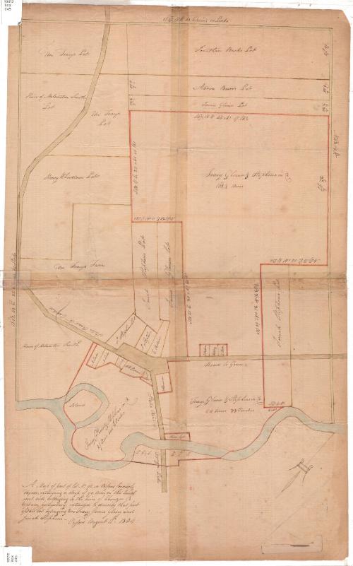
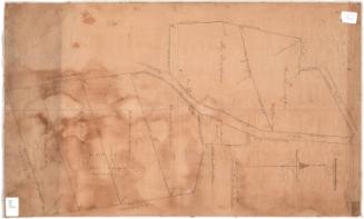
A Map of part of lot No. 92 in Oxford formerly Fayette
DraftsmanDrawn by
Unknown
Date1804
MediumDrawing; black ink and watercolor on laid paper
DimensionsPrimary Dimensions (image height x width): 20 3/4 x 14 1/16in. (52.7 x 35.7cm)
Sheet (height x width): 24 1/2 x 15 1/4in. (62.2 x 38.7cm)
ClassificationsGraphics
Credit LineConnecticut Museum of Culture and History collection
Object number2012.312.22
DescriptionManuscript map of a lot in Oxford, New York, with subdivisions. The map is oriented so that the plot of land appears to run north-south, while in fact it probably ran southeast. An unnamed river (the Chenango) makes up the bottom boundary of the plot. The top and side boundaries are outlined in a light green line, while the subdivisions are outlined in yellow or red. Geographic coordinates of the outer and some of the inner boundary lines are provided, in directions, degrees and minutes. Additionally, the subdivisions' boundary lines are given in chains and lines, and their size in acres and perches.
Label TextSettlers from Connecticut began moving into western New York state during the late 1700s. Uri Tracy, who was born in Norwich, Connecticut in 1764, arrived in the village of Oxford, New York in 1791. Tracy had attended Yale, becoming a Presbyterian minister and missionary. This 1804 map was made when the town was stil in its infancy and shows the property holdings of Tracy and others. Oxford, New York takes its name from Oxford, Massachusetts, but nearby Norwich, New York, the county seat of Chenango County, is named for Norwich, Connecticut.
NotesCartographic Note: No scaleStatus
Not on view


Kellogg & Bulkeley
1910-1915