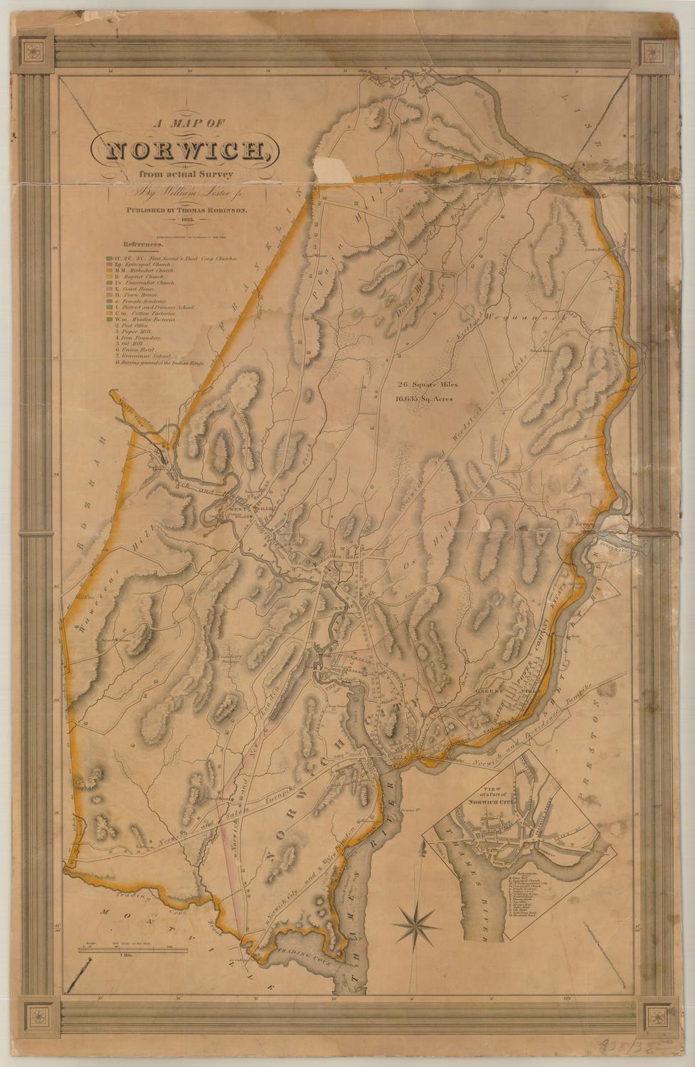
Thompsonville
SurveyorSurveyed by
Chauncey Barnard
(American, 1806 - 1876)
PrinterPrinted by
Nathaniel Currier
(American, 1813 - 1888)
Date1849
MediumLithography; printer's ink on wove paper, lined with linen
DimensionsPrimary Dimensions (image height x width): 21 3/4 x 26 5/8in. (55.2 x 67.6cm)
Sheet (height x width): 22 3/8 x 27 3/8in. (56.8 x 69.5cm)
Mount (height x width): 22 3/8 x 27 3/8in. (56.8 x 69.5cm)
ClassificationsGraphics
Credit LineConnecticut Museum of Culture and History collection
Object number2012.312.20
DescriptionMap of Thompsonville, Connecticut, oriented east-west on the sheet so that Thompsonville appears to be located north of the Connecticut River, while it actually lies east. Houses and businesses are shown, as are buildings owned by the Enfield Manufacturing Company. At the top of the sheet is the factory pond, and crossing the stream that leads from it to the river is the New Haven, Hartford and Springfield Railroad line. On the left side is a numbered list of references that corresponds to many of the buildings on the map. The list contains the name of the store or the owner's name, how many stories it had, and what materials with which it was constructed.
Label TextThompsonville was the site of the site of the largest carpet industry in Connecticut. In this 1849 map, it appears as a classic mill town, laid out along Freshwater Brook, which provided waterpower for the factories as it ran from Factory Pond to the Connecticut River. The New Haven, Hartford, and Springfield Rail Road parallels the river and would soon supercede it as the primary means for transporting the factories' goods to market. Much like later fire insurance maps, this map showing the town in 1849 indicates the materials of which the buildings were constructed, most of them being brick, with either slate or tin roofs. Although no publisher is listed, the prominence given to the Enfield Manufacturing Company suggests that company may have been involved in commissioning the survey and the map.
NotesCartographic Note: 1 inch equals 100 feetConstituent Note: The Nathaniel Currier who printed this map is the same Nathaniel Currier who later became a partner of James Merritt Ives. Currier & Ives (1857-1907) were the most famous American lithographers of the nineteenth century.
Status
Not on view