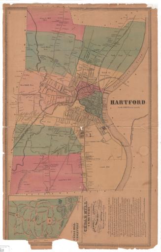
Map of Hartford--1788
MakerMade by
Unknown
PublisherPublished by
Case, Lockwood and Brainard Company
(American)
Date1921
MediumLithography; printer's ink on wove paper
DimensionsPrimary Dimensions (image height x width): 7 1/8 x 10 3/4in. (18.1 x 27.3cm)
Sheet (height x width): 9 3/8 x 13in. (23.8 x 33cm)
ClassificationsGraphics
Credit LineConnecticut Museum of Culture and History collection
Object number2012.312.11
DescriptionStreet map of Hartford, Connecticut, as it existed in 1788. The map is oriented north-south but is presented on the paper in the east-west direction, so that the Connecticut River is at the bottom of the page. The city extends from Soldier's Field in the north, the Connecticut River in the east, South Green in the south, and West Street in the west. A reference list below the title shows the residences and/or business locations of charter members of the Governor's Horse Guards, with corresponding numbers scattered throughout the map.
Label TextThis map was produced to illustrate a history of the Governor's Horse Guards and shows the locations and residences of the original founding members. Originally, Hartford and New Haven served alternately as the capital of Connecticut, and the Horse Guards were formed to provide protection for the Governor as he traveled back and forth between the two cities. Colonel James L. Howard, the author of the book in which the map originally appeared was a Spanish American War veteran and a commander in the Horse Guards.
NotesCartographic Note: No scale.Classification Note: In terms of this project, "historical maps" refer to those made at a later date than the time period depicted.
Subject Note: The map indicates the residences/businesses of members of the Governor's Horse Guards, as well as public buildings. The Horse Guards, created in 1788 in Hartford, originally served as the governor's protection as he traveled between Hartford and New Haven, Connecticut.
From James L. Howard's The origin and fortunes of Troop B: 1788, Governor's Independent Volunteer Troup of Horse Guards. Hartford, Conn. : Case, Lockwood & Brainard Co., 1921.
http://www.worldcat.org/title/map-of-hartford-1788-showing-residence-or-business-location-of-charter-members/oclc/051010464
Status
Not on view