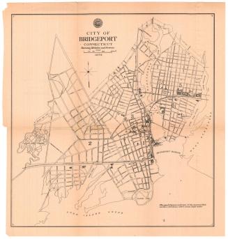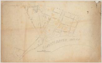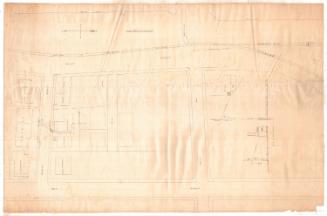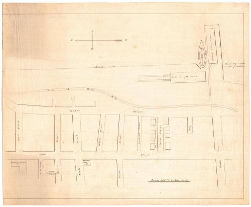
Map of Bridgeport
DraftsmanDrawn by
Unknown
SurveyorSurveyed by
Unknown
Date1872
MediumDrawing; black ink on wove paper
DimensionsPrimary Dimensions (image height x width): 14 9/16 x 19in. (37 x 48.3cm)
Sheet (height x width): 15 15/16 x 19in. (40.5 x 48.3cm)
ClassificationsGraphics
Credit LineConnecticut Museum of Culture and History collection
Object number2012.312.5
DescriptionMap of a portion of Bridgeport, Connecticut, oriented to show an east-west view of the New York and New Haven Rail Road freight house, the steamboat freight house, the dock line, and city streets west of the transportation infrastructure. Streets include Water Street and Main Street running north-south, and Wall, Bank, State, Union, Gilbert, Thomas and Clinton Streets, and South Avenue, running east-west. Notable local landmarks are Sterling House, Ward's Dining Saloon, and Wheeler's Drug Store, all located west of Main Street. Other buildings are drawn on the map, but they are not named. In the bottom right corner in an inscription that reads, "Carpet Bag 300 yds south of South Ave." Very light penciled lines and inscriptions indicate that the map is unfinished.
Label TextThis map shows the area of Bridgeport where Captain George M. Colvocoresses was murdered on the night of June 3, 1872.
NotesCartographic note: Scale: 100 feet to the inchStatus
Not on view