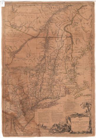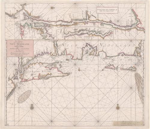
Pas-Kaart van de Zee kusten van Niew Nederland anders genaamt Niew York tusschen Renselaars Hoek en de Staaten Hoek
PublisherPublished by
Johannes van Keulen
(Dutch, 1654 - 1715)
Date1687
MediumEngraving; printer's ink and watercolor on laid paper
DimensionsPrimary Dimensions (image height x width): 20 1/8 x 23in. (51.1 x 58.4cm)
Platemark (height x width): 20 3/8 x 23 1/4in. (51.8 x 59.1cm)
Sheet (height x width): 21 x 24 3/8in. (53.3 x 61.9cm)
Platemark (height x width): 20 3/8 x 23 1/4in. (51.8 x 59.1cm)
Sheet (height x width): 21 x 24 3/8in. (53.3 x 61.9cm)
ClassificationsGraphics
Credit LineMuseum purchase
DescriptionNautical chart of Long Island Sound with numerous place-names in Dutch and English along the coastlines. Separate insets show the Connecticut River and the Hudson River. Place names include Hereford (Hartford), Winser (Windsor), Waters Veldt (Wethersfield), and Zee Broeck (Saybrook). The Connecticut River is called the Versche or Fresh River.
Object number2011.501.0
NotesCartographic Note: Depths shown by soundings.
Date Note: This is the second state of the second printed chart of Long Island Sound and the southern New England coast. The first state of this chart was included in the edition of Johannes van Keulen's Zee-Fakkel (or Sea-Atlas), published in 1684. The chart is based on surveys made by the Dutch just before they surrendered New Netherlands to to the English in 1664.On View
Not on view