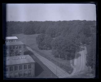
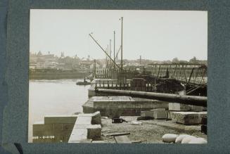
Aerial View of Collinsville
PhotographerPhotographed by
Unknown
Datebefore 1955
MediumPhotography; gelatin silver print on paper
DimensionsPrimary Dimensions (image height x width): 7 1/2 x 9 7/16in. (19.1 x 24cm)
Sheet (height x width): 8 x 10in. (20.3 x 25.4cm)
ClassificationsGraphics
Credit LineThe Newman S. Hungerford Museum Fund
Object number2010.177.2
DescriptionAerial view of a complex of industrial buildings on a river. Brick factory buildings surround a millpond in the foreground. Lettering on the roof of one building reads "COLLINSVILLE;" an arrow points north. A road runs along the the river, with an iron highway bridge at the far left. Railroad tracks cross the road and run along the river to an iron railroad bridge at the far right. Two buildings at the right appear to be railroad stations. Cars are parked along the tracks. Two small islands are in the river. Houses, trees, and fields are on the far shore.
Label TextNote: This photograph appears to show Collinsville before the devastating flood of 1955. The Collins Company ax factory figures prominently in the foreground.
NotesSubject Note: This photograph appears to show Collinsville before the devastating flood of 1955.Status
Not on view